Apple looking to simplify Maps on iPhone with dynamic emphasizing, exaggerating
 Neil Hughes
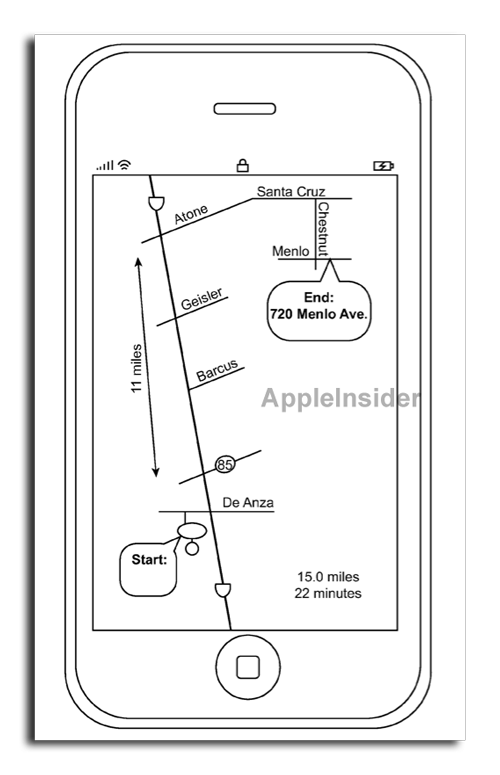
The proposed invention, discovered by AppleInsider, is found in a U.S. patent application entitled "Schematic Maps.". It describes a method in which a mapping application would present users only with information that is most relevant to a given situation.
Apple believes that this concept could provide navigators with a "simple and clear representation sufficient to aid a user in guidance or orientation."
In the application, Apple notes that online mapping services have continued to add information over the years, including satellite imagery, 3D buildings and street views. While this data can be very helpful, the company also believes mapping software has become increasingly complicated, full of information that may not be useful to users.
In addition, Apple believes that mapping software is often not properly displayed on devices with smaller screen sizes, like the iPhone. This small amount of screen real estate, coupled with the plethora of information provided by services like Google Maps, can make mapping software confusing and inefficient for users.
Apple's solution would dynamically generate maps for users based partially on the attributes of the display on which they are presented, to optimize for that screen size. By emphasizing certain landmarks or roads, Apple could allow users to glean necessary information more quickly and accurately than with a heavily populated map.
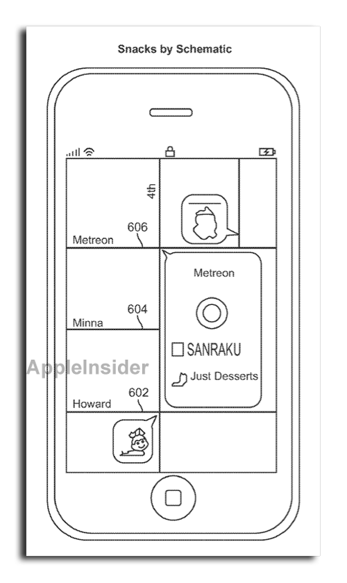
For example, Apple could modify the Maps software for iPhone to automatically "distort" a displayed map when a user requests directions to a certain location. Though the distorted map may not necessarily recreate the real landscape, it would emphasize areas of interest of users to make navigation easier.
Apple could also squeeze more detail onto a screen by not adhering to actual distances. In one example, it suggests a set of directions with route segments at lengths of one mile, two miles, and 400 feet. In order to show detail with landmarks and other visual cues, Apple could distort the lengths of the roads to pack in more information.
These distorted maps could highlight locations, such as gas stations, parks or restaurants, that a user may have interest in. And they could also be used to help a user navigate their route, by emphasizing certain buildings, commonly recognized stores, or physical attributes of the land, like a large body of water.
While some landmarks, like a lake, would always be displayed because of their size, Apple's proposed invention would emphasize some smaller landmarks if they might help a user navigate.
In another example, Apple shows how users could more easily locate their friends with a simplified map display. Features like outlines of buildings and even street detail are automatically omitted, and only streets and friends, or other points of interest, are displayed, providing a user with key information to guide them to the proper locations.
Apple's patent filing, made public this week by the U.S. Patent and Trademark Office, was first submitted in February of 2010. The proposed invention is credited to Jaron Waldman and Moran Ben-David.
The filing is particularly interesting because Apple has shown significant interest in improving mapping software on the iPhone. Since the release of iOS 3.2 in April of 2010, Apple has been relying on its own databases for location-based services.
And this year, when responding to concerns over iOS security and location services, Apple revealed that it is building a "crowd-sourced traffic" service for the iPhone. The new product was said to be planned for launch in the next few years.
The Cupertino, Calif., company also purchased Google Maps competitor Placebase in 2009, and in 2010 it acquired another online mapping company, Poly9. The company's interest in "radically" improving the iPhone Maps application has also been highlighted in job listings advertised by Apple.


 Mike Wuerthele
 Malcolm Owen
 Chip Loder

 William Gallagher
 Christine McKee
 Michael Stroup