New Google Earth 3D cities not as detailed as Apple iOS 6 Maps
 Mikey Campbell
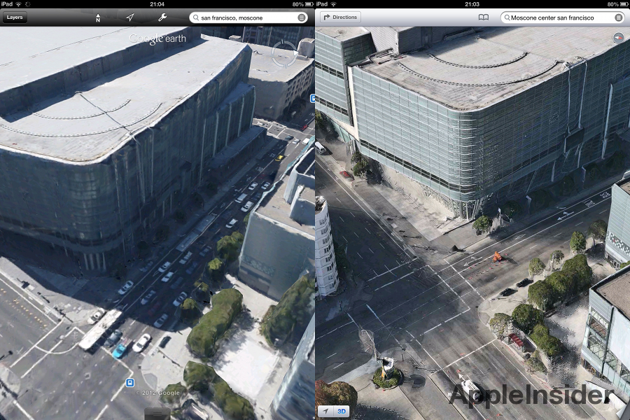
While Google Earth version 7.0.0 became the first iOS mapping app to feature 3D imagery when it rolled out on Thursday, a preliminary comparison to Apple's "flyover" feature in the upcoming iOS 6 Maps app shows Google's solution offers markedly less detail and overall resolution.
It should be noted that the comparison shots of Apple's 3D modeling system came from the as-yet-unreleased version of Maps, meaning image quality may change when iOS 6 is released this fall.
As seen in the screenshots of San Francisco's Moscone Center provided to AppleInsider from reader Tom, Google Earth provides lower resolutions and "blocky" 3D structures. A good example are the green foliage located in the lower right of each image. Google's version shows major signs of post-rendering while Apple's version is crisp and detailed almost down to leaf-level.
View of Moscone Center in Google Earth (left) and Apple Maps (right)
Taking the angle of view and observer positioning into consideration, Google Earth's representation of the Moscone Center is slightly askew. Though it is unknown when these images were taken, the rendering in Apple's Maps app seems to be more accurate as seen by the straight lines on the building's roof. Both versions have trouble rendering the area where the Center's large moving display apparatus meets the roofline, though Google's algorithm appears to warp the image enough to make the building appear globular.
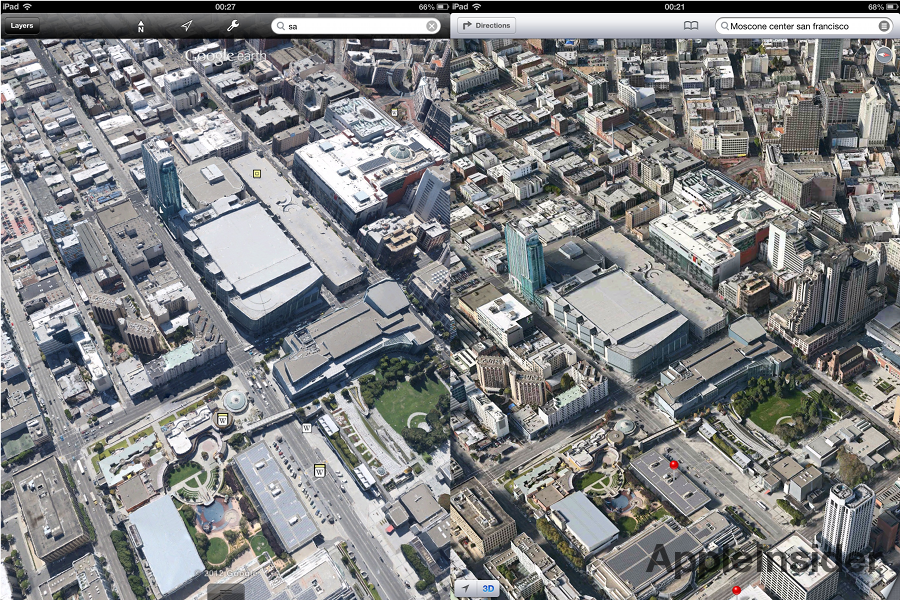
Google Earth (left) versus Apple Maps (right).
As far as speed of rendering 3D objects, the two apps perform somewhat equally, with Google continuing to use the "blurry-to-sharp" solution when processing image data while Apple employs gray grids when data tiles haven't yet been loaded.
As announced during WWDC in June, rendering for Apple's Maps is done in real time and reportedly boasts consistent sharpness in flyover mode. Google, on the other hand, seems to suffer from the same persistent image quality seen in the company's "Street View" and Satellite imagery where zooming in produces increasingly blurry results.
Google Earth 7.0.0 is out now with 3D city support for Los Angeles, Boston, San Francisco, Geneva and Rome with more planned to be added at a later date. The extended 3D view is limited to high-performing iOS products with the iPhone 4S and iPad 2 stated as baseline devices.


 Stephen Silver
 Charles Martin
 Christine McKee
 Malcolm Owen
 Mike Wuerthele


82 Comments
But… Apple's maps are terrible. This can't be. Google must have better maps. There's no way a beta can be better than a release product.
Apples 3D looks better but it needs to be because theres no street view. The more detail the better. Hopefully midsize and smaller cities will be added to Apple's 3D Maps.
I deleted everything Google of my MacBook including Google Earth, after upgrading to ML and reinstalling Little Snitch, there were constant attempts to connect to one Google thing or another, got sick of blocking them. I wasn't really using it much anyway.
-No Street View
-No public transit support
I hope Google makes a 3rd party maps app for iOS.
If there's ever been better proof of Google's copying of Apple, then this is it.
Pick any address in Apple's new map system. Then go to the exact same address using Google Maps.
Almost exactly the same.
Google. You bastards!
This should be Google's new Android logo:
(Sarcasm. Has your browser detected it yet?)