Apple's new iPhoto for iOS uses OpenStreetMap data in place of Google
 Slash Lane
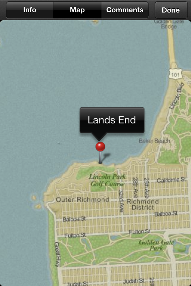
The foundation revealed that Apple is using its data in a post to its official blog on Thursday. Previously, Apple used Google Maps for its Mac version of iPhoto, as well as the rest of its iOS applications.
"The OSM data that Apple is using is rather old (start of April 2010) so don't expect to see your latest and greatest updates on there," wrote Jonathan Bennett of OpenStreetMap. "It's also missing the necessary credit to OpenStreetMap's contributors; we look forward to working with Apple to get that on there."
But Bennett said the foundation is "delighted" to have Apple make the switch from Google Maps to OpenStreetMap. The blog post suggests that Apple did not speak with the foundation before releasing iPhoto on Wednesday, as Bennett said they were "pleased to find" Apple had switched to OpenStreetMap.
Once iPhoto for iOS was released, users immediately began to notice that the software uses a different style of map that isn't credited to anyone. That's a change from all of Apple's previous iOS devices, which have relied on mapping data from Google Maps.
Apple is still using some data from Google for maps in iPhoto, representatives from the company told John Gruber of Daring Fireball. But the use of OpenStreetMap for the map displays in iPhoto signals a major shift for Apple, as the company is expected to develop its own mapping solutions in the future.
In recent years, Apple had acquired a number of mapping companies, signaling that it intends to move away from its dependence on Google. And a year ago, the company publicly admitted it's building a "crowd-sourced traffic" service for iPhone users.


 Christine McKee
 Malcolm Owen
 Charles Martin
 Mike Wuerthele
 Chip Loder


47 Comments
Open Street Map needs to take their stuff to vector, for crying out loud.
Open Street Map needs to take their stuff to vector, for crying out loud.
Yeah, it's not good. I hope Apple isn't planning this for their Google Maps replacement.
It's not like this will see widespread use, but I agree with others that the map data is poor at best. I tried it with a shot I took yesterday and was thoroughly disappointed in the results. On iPhoto on my mba, it still uses Google's mapping, which is leaps and bounds better. The only thing that bothered me was that the photo showed my location as where my wifi router was inside my condo, not outside where I was in the parking lot. I know this is a google issue, not Apple issue as google has clearly added my router into their location mapping.
It looks like mapping from the 18th century.
OpenStreetMap is vector data by its very nature. How it gets rendered is down to the software which makes use of the provided vector data, not the data itself. I'm guessing that the image shown above doesn't make use of the provided data very well at all.
jmgregory - unless your mba has a gps attached chances are that Google will give your location as the location of the router to which you are currently connected - locating a computer as opposed to an iPhone/iPad is pretty much always going to be less accurate due to the limited methods of location available. Having a GPS makes it pretty damn accurate, triangulating cell towers is still pretty good - but if all you have is WiFi, then it's gonna pick your connected router every time.